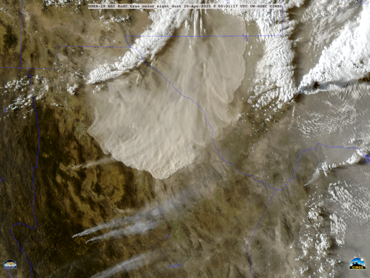
¶Bandwagon takes an experimental reentry vehicle to orbit. SpaceX’s third Bandwagon mid-latitude rideshare mission flew last week, but this time with only three payloads: 425Sat-3 (a South Korean military SAR satellite), a Tomorrow.io commercial weather satellite, and German startup Atmos Space Cargo’s experimental re-entry vehicle. The Phoenix 1 re-entry vehicle uses an inflatable heat shield. It was tested promptly— separating from the Falcon 9's upper stage after 90 minutes and attempting re-entry shortly thereafter. The vehicle splashed down in the South Atlantic Ocean, but it was originally intended for the Indian Ocean east of Madagascar. This change, due to a SpaceX trajectory change announced five weeks before launch because of 425Sat-3’s needs, meant that the spacecraft came in steeper than planned and that Atmos could not recover their spacecraft and only had some contact during descent from a ground station and a plane at extreme range. The company says it still has plenty of data, but it’s not yet clear how well the heat shield performed. There are downsides to ridesharing. |
|
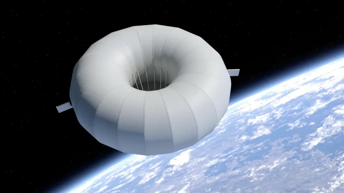 | A backside view of Atmos Space Cargo’s Phoenix reentry spacecraft with its inflatable heat shield (hype video). Credit: Atmos Space Cargo |
|
The Orbital Index is made possible through generous sponsorship by:
  |
|
¶Biomass takes flight. ESA’s Biomass mission, launched yesterday (April 29th) aboard a Vega-C, is the first spaceborne mission to systematically map global Above-Ground Biomass (AGB) using P-band SAR. Operating at 435 MHz (70 cm wavelength), the 12 m deployable reflector (video) penetrates dense canopies to directly sense woody biomass—trunks, branches, and stems—that store the majority of terrestrial carbon at ~200 m spatial resolution. Biomass will employ full polarimetric and interferometric SAR throughout the mission, with an initial tomographic (section-based height mapping) phase over 18 months to generate 3D forest structure maps at ~15–20 m vertical resolution (related paper). This approach shifts from traditional surface backscatter measurement (see related Etc. below) to direct volumetric forest mapping, a first from orbit. The satellite flies at 666 km SSO with a 25-day revisit. Regulatory constraints imposed by the U.S. Department of Defense’s Space Object Tracking Radar Stations prevent P-band operations within line-of-sight of North American and European tracking stations. However, this impacts only ~12% of global AGB and leaves tropical coverage (~66% of global AGB) unaffected (paper). Africa, containing 30% of tropical forests and with AGB uncertainties exceeding 50%, is a primary target; Biomass aims to significantly reduce these tropical biomass estimation errors. Beyond forest applications, P-band’s deep penetration (~5 m in dry snow or sand) enables the mission to monitor ice sheet velocities, detect subsurface geological features, and improve terrain mapping beneath dense vegetation. |
|
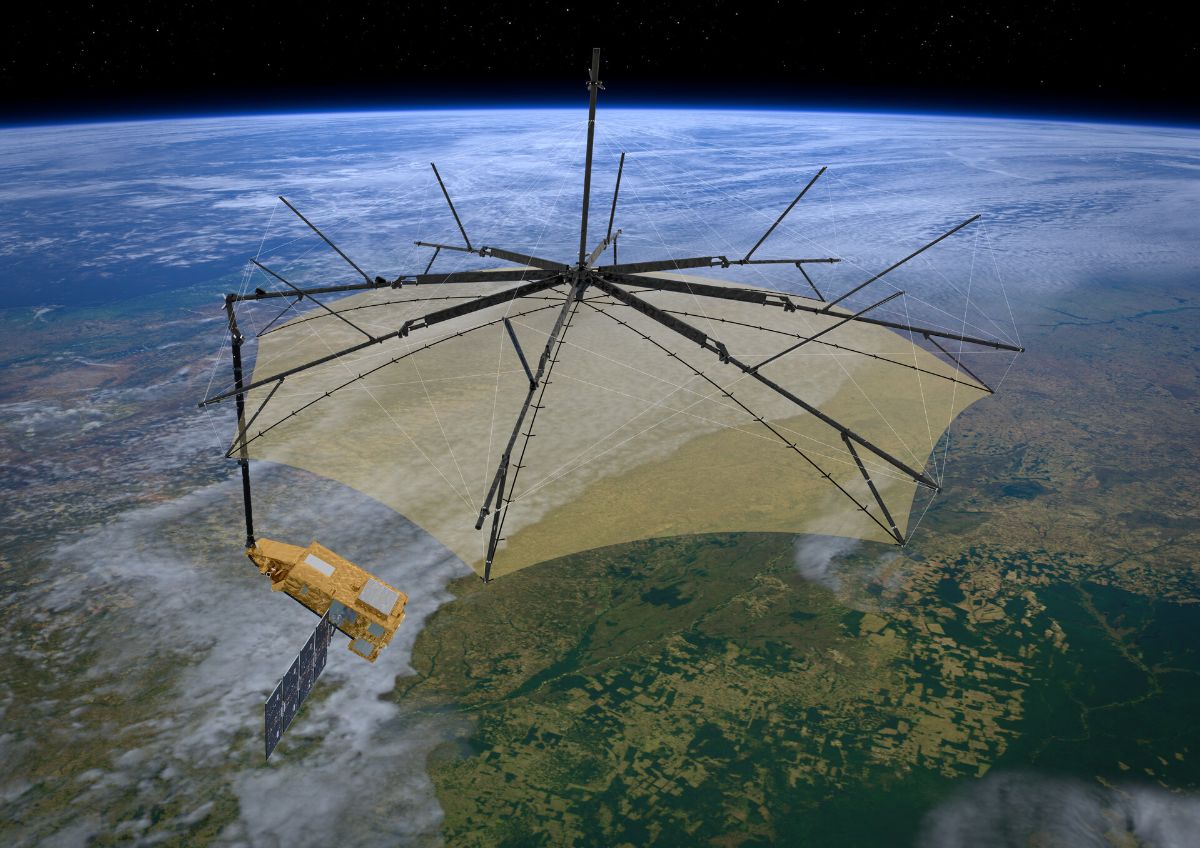 | Biomass rendered with its 12 m deployable reflector in its final position—the reflector takes about 25 minutes to fully expand and tension. Credit: ESA |
|
‹Support Us› Orbital Index is made possible by readers like you. If you appreciate our writing, please support us with a monthly membership! |
|
¶Kuiper 1 puts the tally at 27 to 7,000. Amazon’s first shot at LEO space-based internet launched on Monday aboard a ULA Atlas V 551 and deployed 27 operational satellites to a 630 km, 52° inclination orbit, marking the beginning of its 3,236-satellite broadband constellation buildout. This is a notably high satellite count for Atlas V and suggests substantial miniaturization/mass-efficiency improvements compared to other constellation deployments (launch stream). Unlike the original Starlink sats, Kuiper satellites are laser-linked from day one, with the goal of low-latency global routing with minimal reliance on ground stations. Amazon has committed to an unprecedented 83-launches across ULA, Arianespace, SpaceX, and Blue Origin, securing the largest non-integrated launch capacity procurement in history. Kuiper terminals, priced below $400, undercut Starlink hardware and are clearly targeting quick mass market deployment while focusing on underserved regions. Each Kuiper satellite, massing similarly to Starlink V2 Mini (~600-700 kg), carries beamforming phased-array antennas operating solely in Ka-band. Beyond consumer broadband, Kuiper will integrate directly with Amazon Web Services (AWS), enabling potential cloud-to-space services and some sort of “enterprise-grade connectivity.” Initial service availability is scheduled to begin in late 2025; Starlink had 7,000 satellites and 5M+ subscribers as of Q1 2025. |
|
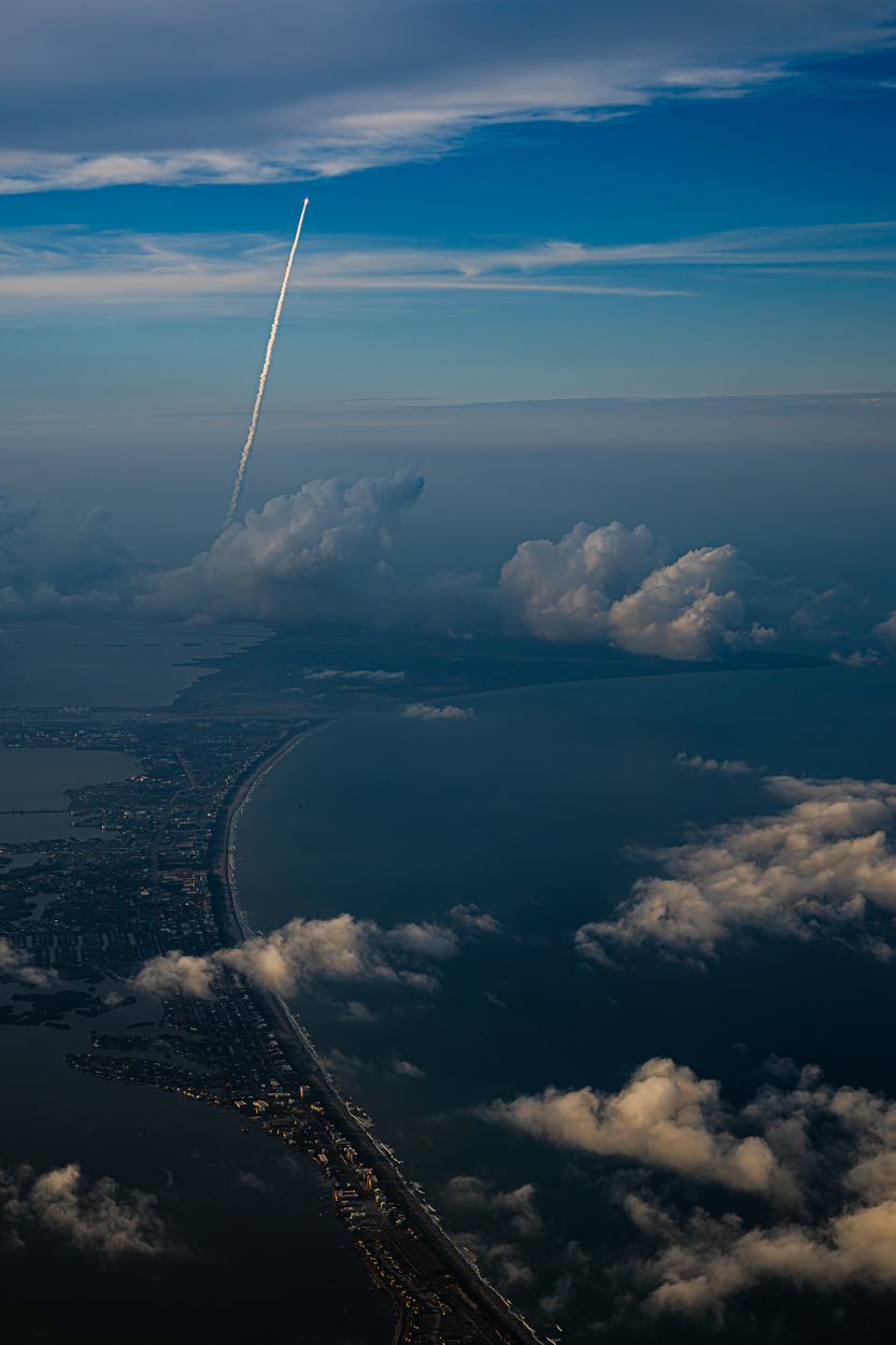 | Amazon’s Kuiper 1 mission launching on an Atlas V rocket from Cape Canaveral, Florida. Credit: John Kraus |
|
| ¶News in brief. China announced an additional array of international payloads for their Chang’e-8 lunar south pole mission, consisting of a South African and Peruvian radio astronomy array, an Italian retroreflector, a Russian surface environment monitor, an Egyptian and Bahraini hyperspectral mineral mapping camera, and some sort of experiment from Iran ● Arizona-based Katalyst Space Technologies acquired Colorado-based Atomos Space (not to be confused with Atmos Space Cargo, above) to combine their in-space servicing capabilities ● The African Space Agency formally opened its headquarters in Cairo ● Northwood Space raised a $30M Series A to establish a global network of phased array ground stations ● A secretive Russian satellite (that might be connected to a nuclear anti-satellite weapons program) appears to be tumbling according to LeoLabs radar data ● The US government canceled their lease for the Goddard Institute for Space Studies at Columbia University which was focused on climate monitoring ● German space traffic startup Okapi:Orbits raised $14.75M in seed funding to enhance their space traffic management solutions ● Apex raised a whopping $200M Series C for satellite bus and parts production ● The FAA’s head of commercial space resigned through the deferred resignation program ● Blue Origin conducted a full-duration 15-second hotfire test of the GS-2 upper stage for New Glenn’s second mission ● China launched three astronauts aboard Shenzhou-20 to Tiangong (drone view) ● Firefly Aerospace’s sixth launch of their Alpha rocket ended in failure during stage separation, with the loss of a Lockheed Martin demonstration satellite ● GOES-18 caught an incredible dust storm moving from New Mexico into Mexico |
|
¶Etc.- The Soviet-era Kosmos 482 Descent Craft is expected to undergo an uncontrolled terrestrial reentry sometime around May 9th. At about half a ton and 1-meter size, the Venera mission was originally intended to visit the surface of Venus, but it never successfully left Earth-orbit. And, being designed to survive a Venusian atmospheric entry, it will almost certainly make it to the ground (or, more likely and hopefully, the ocean).
- Our “sea surface temperatures are rising 4.5 times faster since 2019 than they were at the end of the 1980s.” Meanwhile, NOAA is quietly removing datasets. Relatedly: Inside the desperate rush to save decades of US scientific data from deletion.
- One non-profit stepping up is Climate TRACE, who has started releasing monthly datasets of worldwide greenhouse gas emissions.
- The commercial mass spectrometer MSOLO might get another shot at operating on the Moon successfully. A second version of the VIPER-then-IM-2 spectrometer, which was modified for use on the lunar surface, may fly in 2026 on the Magna Petra commercial rover during its search for Helium-3 with data shared with NASA.
- The Hubble team released some lovely new images to mark the venerable telescope’s 35th birthday. 20 extra years is pretty good for a mission that was originally expected to last 15. 🎂
- An interactive Copernicus Sentinel-1 image of French Guiana. Yellow is tropical forest cover that will be mapped volumetrically for the first time by Biomass (above), which launched from Kourou (far right in the linked image) this week.
- NASA’s trio of CubeSats for the EZIE mission took their first measurements of Zeeman splitting of the 118 GHz oxygen emission line to map auroral electrojets in the upper atmosphere.
- ‘Willy Ley was a prophet of space travel. His ashes were found in a basement.’
- Which would be brighter from your perspective: 1) a supernova, seen at Earth’s distance from the Sun, or 2) a hydrogen bomb pressed against your eyeball and detonating? The supernova, by nine orders of magnitude. 🤯
|
|
An image from JWST’s NIRCam shows a light echo, a phenomenon where light from an explosion (like a supernova) illuminates surrounding interstellar material. These often look like rings that expand over time as light from the event travels outward at light speed and illuminates an expanding sphere of material. This one is near the Cassiopeia A supernova remnant, showing small scale filament structures (e.g. only 400 au across) possibly created by magnetic fields in the interstellar medium. The supernova’s light illuminates existing structures we otherwise wouldn’t be able to see. | 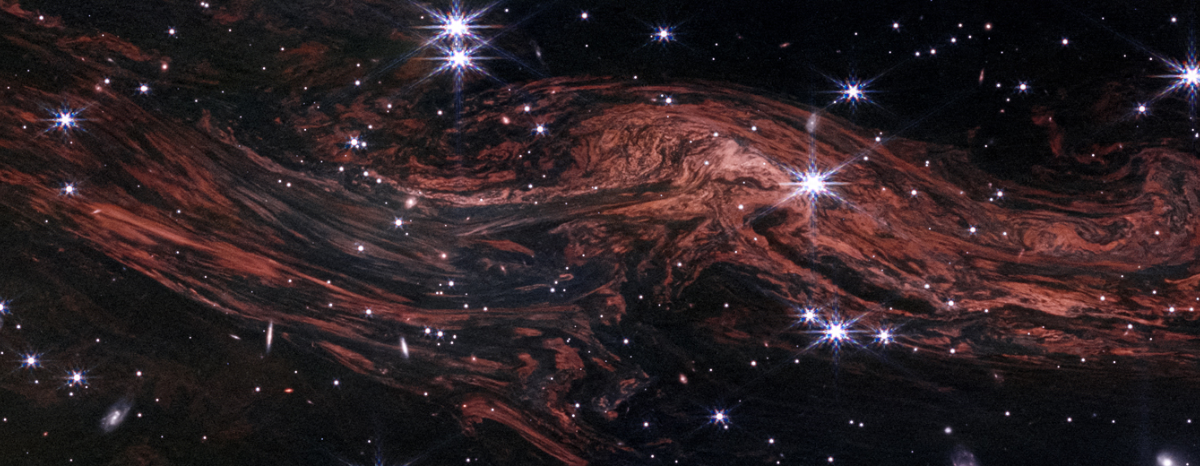 |
|
|